Frozen Wind Vane?
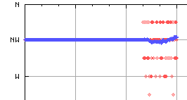
Around 23:00 yesterday the wind vane settled on NW (315°) and sat there until around 07:00 today. I noticed this because the wind direction graph for most of this morning is a straight line:

Of course, if there's no wind at all, the vane won't move, but in that case I don't actually plot a point on the graph — I only plot a direction if there's an associated wind speed.
I suppose it's possible that for all that time the wind vane managed to record exactly the same direction but I've never seen it do this before in all the time I've been running the station. Given how much rain, hail and snow we've had over the last few days I'm wondering if the vane actually froze in place. One bit of evidence that makes me think this might be the case is the fact that the direction settled back into its normal plot (varying around a general direction) at around the same time as the Sun would have started to warm it up (around 07:00 this morning).


2 comments:
What temperature did it get down to last night down there?
I've definitely seen the thing freeze here, before now, but I also noticed a distinct turning point in the weather itself at about 1800hrs last night: pressure peaked, temperature was dropping fast, wind-angle sheared around over 90º, and wind-speed just *stopped* dead.
It dropped just below freezing for a while.
I'm fairly sure that the vane got "stuck" somehow last night - the fact that I recorded wind speeds during all of the early morning suggests there was wind but that the vane wasn't turning.
Post a Comment